
 KINGSTON, R.I. – July 31, 2012 — As an art student at the University of Rhode Island, Ashaway resident Chad Self found himself drawn to sculpture, installation art, and handmade paper. When he was encouraged by a professor to apply for an undergraduate research grant from the University, he added another interest to the mix – oceanography.
The result is a bathymetric map of the seafloor made of handmade paper that he hopes will help to launch him toward his goal of becoming a college art professor.
“Art students rarely received the research grants before, since they’re mostly for science research,” Self said. “But I decided I wanted to bridge the gap between art and science by making something creative from the research they do at the Graduate School of Oceanography.”
He began by investigating the work of the various URI oceanographers until he found Assistant Professor Chris Roman, an ocean engineer who uses various sensing systems and acoustic technologies to create digital maps of the seafloor. These bathymetric maps use different colors to represent changes in topography, an idea that caught Self’s attention.
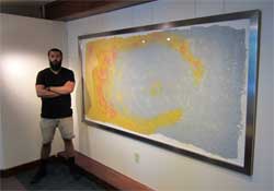 “I love that they use bright primary colors to make these neon topographical maps,” said Self. “I found one map where there were rock formations that created weird ovals on the bottom of the ocean, and I really liked that, since I spent the last year making prints of circular images.”
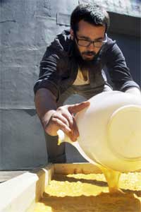
After building an 8-by-4-foot frame and lining it with a bed sheet, he used an outboard motor in a 50-gallon bucket to blend abaca plant fibers with water to make 120 gallons of red, blue, yellow and white pulp. Then it was time to pour the pulp into the frame.
“Process, to me, is everything,” explained Self. “The day of the pour was like an event. It was one of those projects where you spend months planning, but when it comes down to the creation, you have to do it all in one afternoon because there are time limits before paper dries. So I had my bucket and I poured the pulp and used the motion of my arms to make the finished product, starting with a white base and then adding blue and yellow and finally the red, which represents the highest points of the topography.”
Self said he enjoyed learning about mapping from Chris Roman, but it was clear that they had very different perspectives.
“Chris is a scientist, and he thinks in very exact ways — everything is perfect and the numbers are right,” said Self. “My art is a representation of his science, a general idea of what his map is. It’s a transformation from science and the beautiful things in the ocean into an artistic representation of one minute part of it all. Put it at GSO and it’s a bathymetric map, but in some other context it could be seen as something very different.”
The recent URI graduate plans to do more art projects that combine science and art.
“I have actually already done another underwater themed installation that was displayed at Imago Gallery in Warren,” he said. “The installation was titled ‘City Planning for an Underwater Population’ and was inspired in a manner of ways by bleached coral reefs and the way light dances off of the white objects.”
Next up for Self will be to enroll in graduate school with an eye toward teaching at the college level.
“I love the idea of teaching college students,” he said. “There are so many opportunities within the academic world, so many contacts that can be made, and I could still make art and teach others.”