
 NARRAGANSETT, R.I. – September 9, 2014 – A team of scientists from the University of Rhode Island’s Graduate School of Oceanography just completed the first underwater exploration of Navassa Island, an uninhabited United States territory located between Jamaica and Haiti. The researchers mapped the seafloor in the area, investigated the geology of the region, and recorded a number of species of marine life that were not previously known to be found there.
Traveling aboard the E/V Nautilus, the scientists spent two weeks in August focused largely on studying the geologic features that have made the area prone to earthquakes and tsunamis. The two-square mile island sits amid a very active boundary of two tectonic plates.
“We’re interested in trying to understand the stability of the earth in this region to help assess how prone it is to future geologic hazards,” said URI Marine Scientist Dwight Coleman, who led the expedition. “The island has a very steep slope, and we found an area where huge boulders and blocks of sediment slid down the slope thousands of years ago and probably generated a pretty big tsunami.”
Using remotely operated vehicles from 200 to 2,400 meters deep, Coleman and his colleagues collected rock and sediment samples for analysis to better understand the island’s geologic makeup. The island itself is primarily made of an accumulation of ancient corals, but it lies just north of a major fault line that connects Jamaica and Haiti.
The island also is in the middle of the Windward Passage, where ocean water from the Atlantic passes into the Caribbean, generating complex currents and counter-currents and eventually forming the headwaters of the Gulf Stream. The scientists deployed two drifting buoys made by a group of high school students to learn about the currents. Two weeks after being deployed, the buoys were drifting south of Cuba.
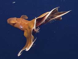
During their investigations, the researchers observed a wide range of interesting marine life, including several species of squid and octopus that were living at depths and latitudes where they were not previously recorded. A number of deep-sea coral species were also found outside of their known range.
“Because of the region’s tectonic history, we already understand quite a bit about its geological history, but until you actually go down to the seafloor, you don’t really know what you’re going to find,” Coleman said. “That’s the whole purpose of Nautilus expeditions – to go somewhere that no one has gone before.”
The expedition has led to collaborations with Haitian scientists and plans for a return trip to continue studies of the region. “It has a rich maritime history, so there’s a possibility that we might find old shipwrecks in a future expedition,” Coleman said.
Marie-Helene Cormier, a marine scientist at the Graduate School of Oceanography who participated in the expedition, is also thinking about follow-up studies with faculty from the University of Haiti.
“We spent some time exploring the underwater trace of the Enriquillo Plantain-Garden fault, the same fault that ruptured in 2010 in a devastating earthquake near Port-au-Prince,” Cormier said. “We discussed the possibility of surveying the extension of the fault beneath Lake Azuei in Haiti, using a small Haitian ship and URI portable geophysical equipment. I am very interested in pursuing this further.”
The Exploration Vessel Nautilus is managed by The Ocean Exploration Trust, a partner of the University of Rhode Island’s Graduate School of Oceanography and Inner Space Center. The public can view video highlights and images of the biology and geology discovered during the expedition at Video and tune in to live ongoing coverage.
Pictured above: A dumbo octopus observed off Navassa Island in the Caribbean by University of Rhode Island researchers aboard the E/V Nautilus. (Credit: Ocean Exploration Trust)