NARRAGANSETT, R.I. — Sept. 10, 2018 – Isaac Ginis said that it is notoriously difficult to forecast hurricanes in New England. When storms move north, they develop a more complex wind structure than those remaining in the Southeast and Gulf of Mexico, their paths become more erratic, and the region’s complicated topography makes predicting their movement over land especially challenging. In addition, the relatively short rivers in New England fill up quickly when it rains and cause more flooding than in many other areas.
A new series of hurricane models Ginis and his colleagues are developing at the University of Rhode Island’s Graduate School of Oceanography will address these difficulties and make forecasting hurricanes in New England more precise. The models will even predict the storm impact on particular roads, bridges and buildings in the area.
“We’re working to improve existing models and create new modeling capabilities to address concerns about coastal flooding due to storm surge, inland flooding due to heavy rainfall and the challenges of predicting winds over land,” said Ginis, a professor of oceanography who was the first to incorporate ocean conditions into hurricane models. His models have been used by the National Hurricane Center for more than 20 years.
Funded by the Department of Homeland Security in partnership with the University of North Carolina at Chapel Hill, this research effort will result in a real-time forecast system for southern New England that will enable public officials and first responders to get accurate updates every 30 minutes.
The URI team will improve the existing Advanced Circulation Model used by Homeland Security, the National Oceanic and Atmospheric Administration and other agencies for storm surge prediction. The new version will feature much higher resolution for the New England area and incorporate new capabilities, such as combined coastal and inland flooding forecasts and predictions for storm impacts on critical infrastructure.
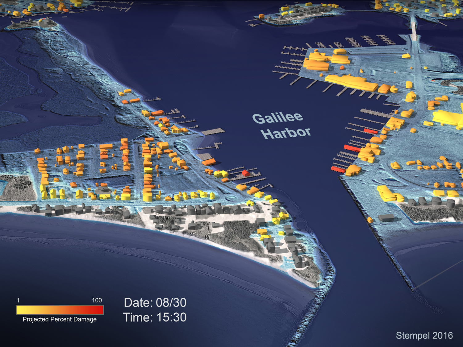
“We’re going to deliver a fully-automated system with all hazard predictions, wind speeds, coastal and inland flooding predictions and 3D visualizations in one forecast system,” he said. “It will be the first place in the country to have a fully-integrated hazard and impact analysis.”
Ginis and his research team collaborated with the URI Department of Marine Affairs and the Rhode Island Emergency Management Agency to interview facility managers around the state to identify vulnerabilities and concerns about buildings, roads, bridges and other infrastructure. For instance, a fire chief indicated that 120-mile-per-hour winds would likely disable the department’s communications antenna. Another noted that eight inches of water on a roadway would prevent emergency vehicles from reaching those in need.
“All infrastructure has a threshold when it will stop functioning properly,” Ginis said. “We’ll be able to predict those thresholds and mark on a map in real-time when those thresholds are reached.”
Three-dimensional visualizations of storm impacts will also be developed and integrated into the hurricane hazard prediction models. These tools will enable emergency managers and first responders to more clearly understand storm impacts.
In addition, the forecast models will feature refinements to existing wave and storm surge models, enabling more accurate predictions of coastal flooding.
“To do that, we need to have very high spatial resolution of the coastline, bathymetry and topography,” Ginis said. “We’ve refined our calculations to improve the resolution of the model by a factor of 10.”
To predict inland flooding, he has partnered with a hydrologist at Florida State University to create a model that will forecast the flooding of the various river watersheds in the region.
According to Ginis, where most hurricane models tend to go wrong is in the prediction of wind speed over land because of the change in friction between the water and the land.
“When a storm makes landfall, the wind experiences major changes that are affected by the local topography,” he said. “You have to take into account the area’s land cover — forest, crops, urban — to predict the surface winds at high resolution over those land uses.”
Ginis recently made a presentation about this element of the model at a hurricane conference in Florida, and the National Hurricane Center has already expressed interest, since no existing models are as refined for predicting hurricane wind speed over land.
The University of Rhode Island’s Graduate School of Oceanography (GSO) is one of the world’s premier oceanographic institutions. Founded in 1961, the GSO has built a reputation for excellence in deep water oceanographic research, coastal planning and management, sustainable fisheries and monitoring the health of Narragansett Bay. With operations worldwide, GSO research, education and outreach programs train the next generation of scientists and policymakers, while ensuring Rhode Island’s K-12 teachers and students gain an appreciation for the importance of ocean science through a variety of hand-on programs.
On Nov. 6, Rhode Islanders will vote on referendum No. 2, a $70 million higher education general obligation bond that includes $45 million for upgrades to the Narragansett Bay Campus. If approved, proceeds from the bond will be used to improve the GSO’s pier (required to accommodate a newly awarded Regional Class Research Vessel from the National Science Foundation worth about $125 million), construct a 20,000-square-foot Ocean Technology building, a Marine Operations building and fund other necessary improvements to campus facilities