 NARRAGANSETT, R.I. – February 10, 2009 – Two high-tech devices that measure wind speeds in different ways are being installed at the University of Rhode Island’s Bay Campus in Narragansett to demonstrate their capabilities and collect data for research on hurricane forecasting, assessing the state’s wind energy resources, and other uses.
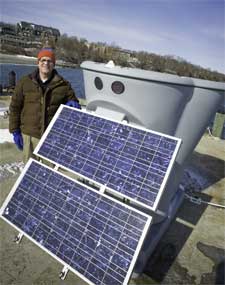
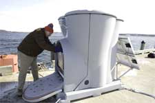
A Triton sonic wind profiler was installed on the Bay Campus dock in early January by Second Wind Inc., which designs and manufactures technologies that collect wind measurement data. The $60,000 device, on loan to the University through February, emits acoustic pulses vertically into the atmosphere every 2 seconds to capture wind speeds at varying heights from 20 to 200 meters above ground.
“The acoustic pulse bounces off turbulent eddies in the atmosphere caused by temperature variations or variations in moisture levels. The device looks for a change in frequency of the acoustic signal that reflects back and interprets the wind speed and direction,” explained John Merrill, a URI atmospheric chemist and professor of oceanography.
 The sonic wind profiler is solar powered and transmits its data via satellite in near real-time. The company loaned the device to the University to demonstrate its capabilities to URI scientists and to learn more about how it responds to the sound of waves and other environmental noises at coastal locations.
Based on the first two weeks of data, Merrill was somewhat surprised at the wide variation in wind speeds at different heights. He said the data could be used in studies of air/sea interactions, as well as in his air quality research.
“I use a weather balloon to measure ozone levels at different heights, but with the wind profiler I can get a more detailed picture of how the air is moving and apply it to our understanding of our ozone problems,” Merrill said.
Later this winter a hurricane hardened weather station will be installed on a 10-meter pole at the Bay Campus to aid in the studies of hurricanes. Made by WeatherFlow Inc., it is designed to measure hurricane force winds of up to 140 miles per hour.
“There are no existing weather stations that belong to the National Weather Service that can withstand such strong winds,” said URI Professor Isaac Ginis, who has developed one of the most accurate hurricane forecasting models in use by the Weather Service. “Typical weather monitoring stations fail when hurricanes come ashore, so we have too little data about how strong the wind is during hurricane events.”
The hurricane hardened weather station at URI will be one of a network of similar stations installed along coastal areas in the eastern United States. Most will be located on the Gulf Coast and in Florida. The URI station will be the first in the Northeast.
“They were looking for a location with an open exposure to the water, and they are interested in collaborating with us on the analysis of the data,” Ginis said. “We will not only get access to the data from our station but to all the stations in the network. That will be a big advantage to us.”
Ginis said that the new weather station will help him improve his hurricane forecasting abilities by using the data to validate his models.
“As well as providing much needed data from land-falling hurricanes, the network will also directly benefit local communities, emergency management groups, coastal inundation studies, Coast Guard search and rescue operations, research into utilities and building codes, and a host of other diverse applications,” said David Morris, WeatherFlow meteorologist and hurricane network coordinator.
All costs associated with the installation and maintenance of the weather station will be underwritten by WeatherFlow, Inc.
URI Department of Communications & Marketing photo by Michael Salerno Photography.