
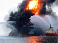
 The oil rig explosion and resulting oil spill in the Gulf of Mexico has placed experts from the University of Rhode Island right in the middle of another major international news story.
Coast Guard Rear Admiral Mary E. Landry, who earned her master’s degree in Marine Affairs from URI in 1995, is overseeing efforts to stop the flow of oil from the well and monitor clean-up operations. About 42,000 gallons of oil are released into the water each day, and it is expected that it may take as long as 45 to 90 days to stop the flow.
“We have no shoreline impact at this time, and we continue to work with the Gulf Coast States to ensure the prepositioning of oil skimmers and booms so we’re prepared to attack any spill if it migrates to shore,” Landry said at a press conference on Monday.
Efforts to track the spread of the oil and assess its potential impact on the environment are being conducted using software programs developed by Applied Science Associates, a Wakefield-based company that was started by Ocean Engineering Professor Malcolm Spaulding. He said that the first step is to determine where the oil is going and what environments may be impacted. The company’s efforts are being led by Deborah French McCay, who received her doctorate from URI’s Graduate School of Oceanography in 1984.
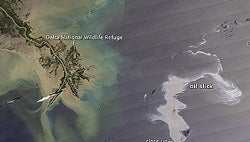 “This thing is 40 miles off shore, so it will have a wide transport path,” Spaulding said. “What they’re worried most about is if it gets close to the coast and into the marsh and bayou system. That could have substantial environmental impacts.”
Spaulding said that the company’s oil spill modeling system programs, OILMAP and SIMAP, are the most widely used models in the world for tracking the movement and assessing the impact of oil spills. Many countries around the world have adopted OILMAP as part of their national oil response system. SIMAP has been routinely used to assess damages from most major oil spills, and it has been in use for the Gulf of Mexico spill since the beginning of the incident through the National Oceanic and Atmospheric Administration’s Natural Resources Damage Assessment Office.